Southeast Texas Hurricane Evacuation Study
Project Front Page | Last updated: Tue Mar 10, 2026
| Presentations | Planning Zones |
Previous Studies | Team | Sponsors
This page provides a central hub for project
updates, events, and links to the Planning Atlas
and related resources. It supports the hurricane evacuation study by keeping
participants and stakeholders informed about meetings, draft reports, and key
materials. The site is a working resource and will evolve throughout the
project. For questions or requests, contact Alexander
Abuabara at abuabara@tamu.edu.
Resources
Reports
Updated
hazard analysis for coastal counties including Brazoria, Chambers, Galveston,
Hardin, Harris, Jackson, Jasper, Jefferson, Liberty, Matagorda, Newton, and
Orange
·
Southeast Texas Hurricane Evacuation
Study Final Report
·
Southeast Texas Hurricane Evacuation
Study Hazard Analysis
Southeast Texas Hurricane
Evacuation Scenarios
Mapping Applications
Interactive
geospatial data resources for evacuation and vulnerability analysis
- Southeast Texas Hurricane
Evacuation Planning Atlas
- Southeast
Texas Evacuation Zone Dashboard
- Texas Atlas Open Data Portal
County Evacuation Zones Mapbook
(Printable PDF by Page Size)
County
Level Evacuation Clearance
·
12-hr Scenario Clearance Curves (Jan
2026)
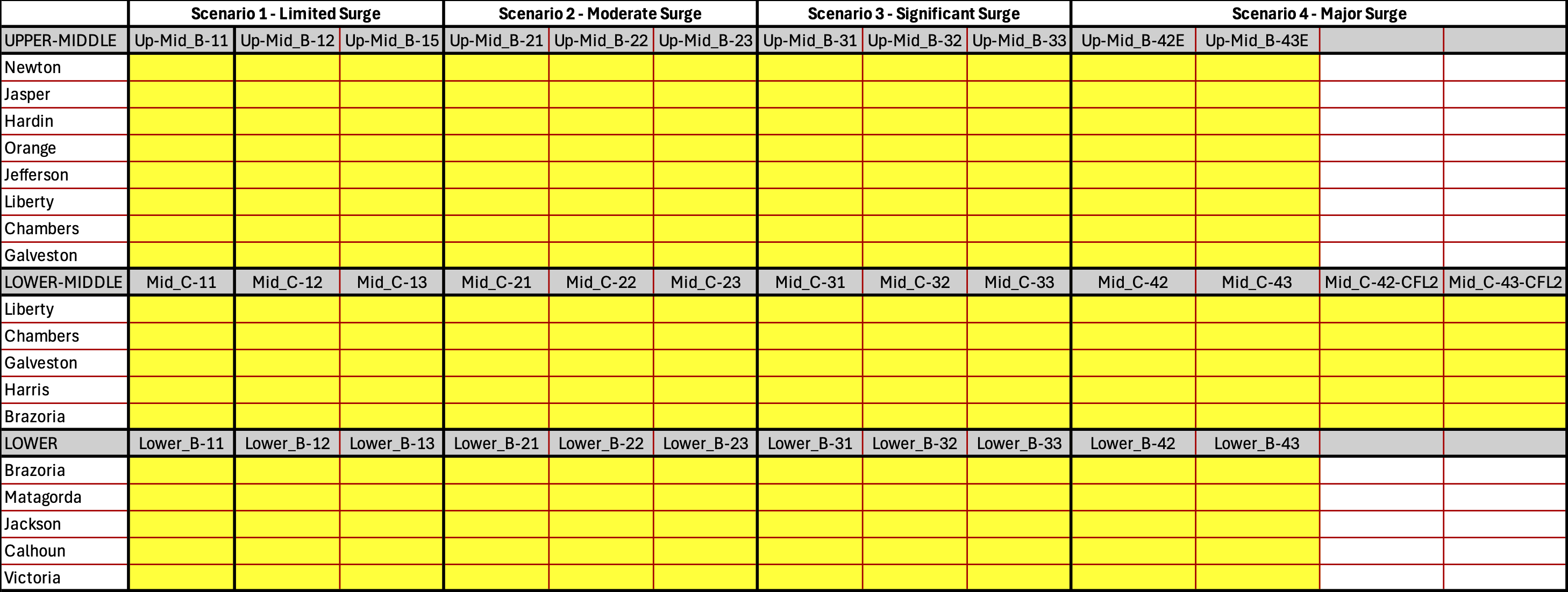
Using a custom-developed script, we processed the evacuation results from RtePM
for multiple runs, reading a GIS shapefile of block-level results, aggregating
vehicle counts by zone and time interval, and transforming those counts into a
"cumulative evacuated proportion" time series per zone and scenario.
The script parses zone labels into county and planning-zone categories,
standardizes the planning-zone names and ordering, and for each county
generates a graph consisting of (1) line curves of evacuated proportion over
time for all planning zones in that county and (2) a small summary table
reporting the estimated time (via linear interpolation) when each curve reaches
50% and 90% evacuation. The table layout below shows which graphs are
available for each county under each scenario.
Presentations, Meetings,
Workshops
Final Presentations
Date:
March 16, 2026
Location:
Virtual
Behavioral and
Transportation Workshops
Date:
December 8, 2025
Location: Virtual
- Transportation Analysis Evacuation
Scenarios Workshop
(3 virtual meetings, same slides presented at each meeting.)
Date: June 4, 2025
Location: Virtual - Upper Planning Zone
Date: December 2, 2024
Location: Virtual - Middle Planning Zone
Date: November 18, 2024
Location: Virtual - Lower Planning Zone
Date: November 18, 2024
Location: Virtual - Kick-off Meeting
Date: October 28, 2024
Location: Virtual
Evacuation Zones Workshops
Packet for All the Counties in
the Upper Planning Zone
Hardin County Surge
and Potential Zones
Date:
April 1, 2024
Location: Orange County Convention and Expo Center
11475 FM 1442, Orange, TX 77630
Packet for Chambers County
Packet for
Galveston County
Packet for Harris County
Packet for Liberty
County
Date:
March 18, 2024
Location: Walter Hall Park
807 State Hwy 3 N., League City TX 77573
Packet for Brazoria County
Packet for Jackson County
Packet for Matagorda County
Date:
April 15, 2024
Location: Lake Jackson Civic Center
333 TX-332, Lake Jackson TX 77566
Vulnerability Analysis Kick
Off Meeting
- Slides / Meeting
Recording on YouTube
Date: February 15, 2024
Location: Virtual
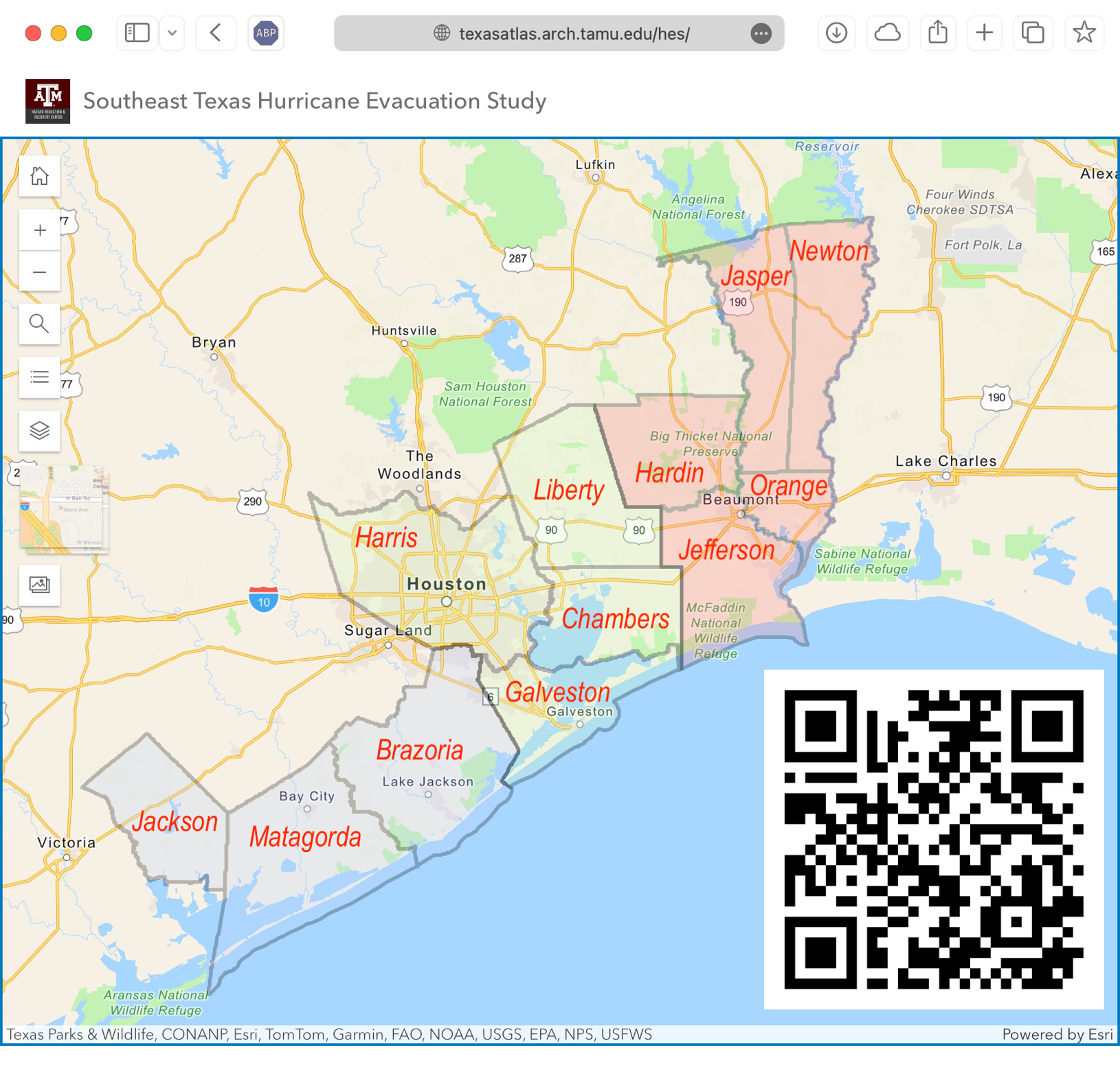
Planning Zones
In previous Hurricane
Evacuation Studies undertaken by the National Hurricane Program, the Texas
coast was divided into four evacuation study areas: the Rio Grande Valley
(Hidalgo, Cameron, & Willacy), Coastal Bend (Kenedy, Kleberg,
Nueces, San Patricio, Aransas, Refugio, Calhoun, & Victoria), Houston/Galveston
(Jackson, Matagorda, Brazoria, Harris, & Galveston) and Sabine Lake
(Chambers, Liberty, Jefferson, Hardin, Orange, Jasper, & Newton).
This time, the 12 counties
comprising the Houston/Galveston and Sabine Lake study areas have been combined
into one single study area, the Southeast Texas Hurricane Study Area. To
facilitate the Hurricane Evacuation Study process, particularly when holding
workshops to work more closely with county/municipality and other stakeholders,
the 12 counties have been divided into three planning zones: Upper, Middle, and
Lower. The counties in each planning zone are as follows:
- Upper: Newton, Jasper, Hardin, Orange,
Jefferson
- Middle: Harris, Galveston, Liberty,
Chambers
- Lower: Brazoria, Matagorda, Jackson
Previous Studies and Other
Presentations
- Transportation EndPoints Presentation - September 23, 2025
- Risk-based
Evacuation Zone Planning for the Texas Gulf Coast - COA Showcase 2025
- Risk-based Evacuation Zone
Planning for the Texas Gulf Coast
- Risk-based Evacuation Zone
Planning in the Rio Grande Valley and Coastal Bend
Coastal
Bend Hurricane Evacuation Study
- Planning Atlas: Coastal
Bend Hurricane Evacuation Study
- Behavior Survey Report
- Transportation Analysis
Report
- Scenarios Definitions
Meeting
- Evacuation Zone Report
- Vulnerability Analysis
Report
Rio
Grande Valley Study Area Hurricane Evacuation Study
- Planning Atlas: Rio Grande
Valley Hurricane Evacuation Study
- Transportation Analysis
Report
- Evacuation Zone Report
- Vulnerability Analysis
Report
Team Members
- USACE Galveston District
Kyle Donlevy kyle.a.donlevy@usace.army.mil
Gerald Gains gerald.d.gaines@usace.army.mil - FEMA Region 6
Arianne Thomas arianne.deruise@fema.dhs.gov - Texas Division of Emergency
Management
- Texas A&M University
Walt G. Peacock wpeacock@arch.tamu.edu
David Bierling d-bierling@tti.tamu.edu
Darrell Borchardt d-borchardt@tti.tamu.edu
Doug Wunneburger d-wunneburger@tamu.edu
Alexander Abuabara abuabara@tamu.edu
Sponsors